Iceland Trip Part 7 - Magnús, Westfjörds and Snaesfellsnes Peninsula
We had reason to stay in Reykjavik after dropping Judy and John off at the airport, that night we had dinner plans with Ann’s classmate from university, Magnus, and his wife Yayoi. Dinner was delicious, the company was fantastic and Magnús invited us for a hike the next day. We gladly accepted.
Magnus took us to one of his favorite hikes in the hills southeast of Hafnarfjör∂ur (just southwest of Reykjavik). And yes, it was quite the climb.
As with so many places in Iceland, the landscape was formed by centuries of volcanic activity. This area is part of the fault that includes the recent eruptions near Grindavik.
The formations we hiked are quite old and therefore less rough than new formations and with plenty of life having found a foothold over the centuries.
As Magnús explained, there are several “hot spots” beneath Iceland and as the Earth’s mantle rotates over the hotspot, the volcanic activity has been making its way in a southwesterly direction along the fault line, with the Grindavik eruption its latest break-through.
The views from the top were spectacular, with the skies clear enough to see Hafnorfjör∂ur and Reykjavik in the distance.
And the signs of different geological processes were everywhere, giving us lots to look at along the way back down.
Afterwards Magnús treated us to lunch at the University of Reykjavik, where he works, and we got to tour the university building and surrounding area while Magnús took care of some University business.
We hadn’t done much trip planning for the second part of our trip, so we decided to spend an extra day in Reykjavik to chart a rough itinerary and, once that was done, we decided to walk into town again. All we can say is that it is a very lively and interesting city, in a Eugene sort of way.
And no, I didn’t need a hair cut so I can’t tell you how the place actually works.
We had no real destinations in mind, we just wanted to wander a bit and stretch our legs after our serious hike the day before. We definitely came across some interesting street art.
We of course had our point-and-shoot cameras with us, which gave us plenty of opportunity to pause our walk while we made images.
The next day we were off again. During our planning discussions Ann mentioned she would be interested in returning to Landmannalaugar. Given it was September and the first snows would be coming soon along with possible road closures, we decided to make that our first destination for the second half of the trip.
This time we decided to come in from the north, on F208. While there were some beautiful locations on the drive,
the road conditions progressively worsened and as we drove onward, we wanted nothing more than to get to our destination.
Once there, we headed out for a quick exploration to the final canyon of our hike with John and Judy. The wide river basin offered us some lovely shots as we walked from camp,
making us stop several times because the opportunities were just too good to pass up.
Eventually we hit our canyon and, well, I’ve done one post that included images from that shooting session.
Unfortunately, the weather turned increasingly bad for us. The next day we delayed our morning shoot to let the heavy rain pass, but were faced with alternating periods of breaking skies and squalls of heavy drizzles. We had our rain gear on, but it isn’t fun to photograph (or hike) in the rain. This time we hiked farther up into the river valley.
At one point we saw the strangest sight, one we’ve never seen before. I’ve mentioned that we ran across a lot of rainbows in Iceland. Well, at Landmannalaugar we came across . . . I don’t know what to call it. There was no real discernible rainbow arc, but a rainbow color spectrum was painted on the hillside. It definitely was not normal.
We stood in amazement for several minutes, as did the hiker who stopped and had enough sense to turn around (probably wondering what the two weirdos in front of her were looking at).
Not long afterwards, the landscape returned to its normal color, no rainbow per se having ever appeared.
We then continued exploring farther and farther up the river into the valley, photographing as we went along.
We decided to turn back when the mountains in front of us suddenly had dark, foreboding clouds above them. We kept checking behind us as we hiked back to camp, realizing when the mountains disappeared behind a wall of grey that we weren’t going to make it back in time. It was pouring down rain when we got to the bimobil and we were drenched. That was it for the day.
It was a wild, windy night until about 2:00. Then, as the weather app predicted, the winds died and the temperatures dropped. By morning it was very, very cold and the mountains all around had snow.
The weather app forecasted decent weather that day, but then a week of heavy, bad weather for the highlands. The only part of the county that had a reasonable chance of intermittent weather was the Westfjords, so instead of staying for another day, we decided to take our time driving out from Landmannalaugar and, as they say, “Head west young man!”
The plan was to stop at a couple of locations we’d not visited where F225 intersects F208, and to take F225 out of the area. As we left the valley where Landmannalaugar is located, the skies started to clear, and we found a lovely photo opportunity as we drove along F208.
The air was crisp and the distant mountains were topped with snow.
At the F208 - F225 intersection, we turned right instead of left for a side-excursion. We drove a bit and I hiked up to the top of Ljótipollur to take a look down into the crater lake. While the Icelandinc name Ljótipollur may sound a bit exotic if not romantic, it translates into “Ugly Puddle.” It is definitely not that.
While I had hiked up the crater, Ann spent time at a lower elevation, taking advantage of the elevated views the location offered of the landscape. On the way down, I too stopped for a shot or two.
From there we continued our excursion into the unknown and truly felt all alone in the landscape.
We drove for several kilometers across a flat, barren, landscape surrounded by colorful hills and lakes
The road led to some power lines and the maintenance road that ran along it. I remembered the power lines from our drive into Landmannalaugar on F208, so we followed them back to a known route.
Still, there were plenty of kilometers where we saw nobody else and we made several stops to enjoy the views.
Eventually we hit F208, headed south until we hit F225 and then we headed west. We stopped a couple of times to enjoy the sights, and one time to make photographs of some amazing lava formations.
Once back on pavement, we drove to a campsite near Faxafoss where we stopped along the way to have a late lunch at the tomato restaurant Fri∂heimar. While we missed the company of John and Judy, it was nice to have a meal out.
The next morning we continued the long westward drive through farm country and double rainbows . . .
. . . past Þingvellir, where the North American and Eurasian tectonic plates meet . . .
. . . and finally up and over the mountains that lead into the Westfjords.
We continued driving in the rain, with few real stops, and eventually camped at Drangsnes.
The next morning the weather hadn’t improved, but we continued nonetheless, knowing it was worse back from where we had left. One of the places I’d flagged to stop at was the SaltWerk “factory,” which one of our guide books said was worth visiting. You can pretty much find Saltwerk salt in all of the grocery stores, so we expected an interesting facility. As their adverts say (image below from one of them), they draw from some of the cleanest seawater on earth.
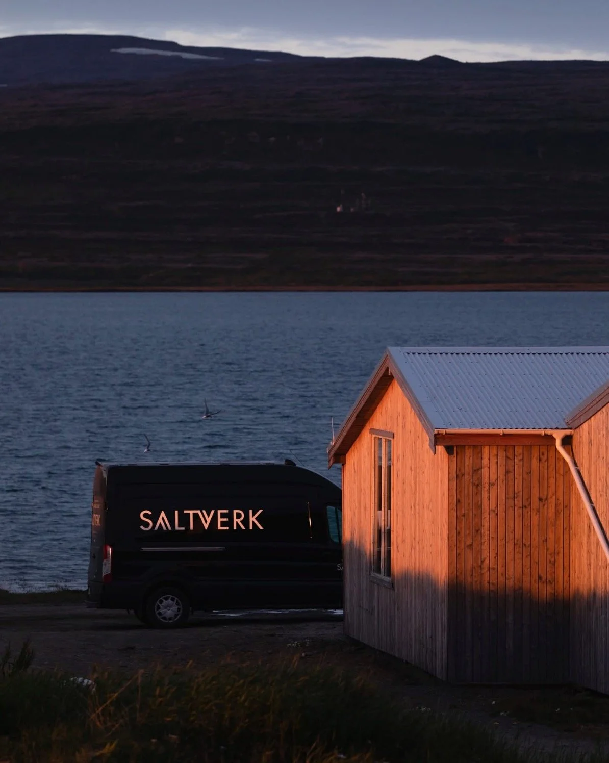
SaltWerk Ad Photo
Well, I don’t know what we were expecting, but it’s an amazingly small operation for the amount of salt they sell. Their “gift shop” is . . . quite small and the description “modest” is apt. One of the workers was surprised and quite pleased that we showed up. They are quite out of the way!
As you can see, their second operations building isn’t much to behold.
And the inside of one wing of their main facility is nothing more than a bunch of vats where saltwater is reduced to salt. All we have to say is that all of their salt we’ve tried (and we brought home quite a bit) has been EXCELLENT!
From SaltWerk we drove in and out of the fjords heading northwest making our way around one of the main peninsulas.
It was heavily overcast and raining much of the time.
(Un)fortunately, that didn’t matter much because, to our amazement, despite the many beautiful locations, there were very, very few pull-outs or formal stopping points where you could appreciate the scenery. So we accepted that we wouldn’t be making many photographs and enjoyed the ride.
We ended the day in Isafjör∂ur, where we stopped for a meal and wandered around the harbor area taking advantage of a lull in the rain.
We camped for the night at the campground at the base of Bunárfoss. We could hear the waterfall all night . . . when rain wasn’t pelting the roof!
The next day we took the long tunnel through the inland mountain and came out on yet another fjord. The rain was light and periodic and, for once, we found a nice rest stop that gave us a lovely view across the fjord.
But as we continued our drive, the rains returned. Every time we thought it would clear up a bit, the clouds would close and the rains would return.
Dozens of mini-waterfalls would appear on the sides of the fjords, indicators that the rain was persistent.
As we approached Dynjandi and the smaller waterfalls below it, not only did the rains let loose again, we discovered the road to and from it was under very heavy construction, with delays to and from it. We decided to drive onward.
We kept driving, enjoying the landscape until we hit the southern end of the Westfjords.
When we finally found a good pull-out to look around a bit, we also checked the weather app. The forecast was not promising for the Westfjörds.
The interior of Iceland was still going to be a mess, but now it also included the Westfjörds for the next couple of days. The best option was the Snaesfellsnes Peninsula, just south of the Westfjörds, where it was supposed to clear up . . . the next day or so.
So we continued our drive through the beautiful Westfjörds in inclement weather, knowing we’d likely not have any real opportunities for photography.
But that didn’t keep us from enjoying the beautiful sights as we drove.
t’s a wild and beautiful landscape, and if we were to return, we’d likely want to spend more time here . . . in much better weather.
The weather would clear a bit, then worsen a bit throughout the day as we drove onwards enjoying the scenery.
We had planned anywhere from 4 to 5 days in the Westfjörds, but the weather told us they wouldn’t be enjoyable (read: dry), so what could we do?
Change plans (again). So despite traveling in two days what we’d planned for in 5, and skipping a lot of potential locations, we were grateful for what was offered.
We eventually turned eastward onto 54, the road that runs along the north side of the Snaesfellsnes Peninsula. In grand Icelandic tradition, this major road was a graveled dirt, now partially mud, road. Off in the distance we saw hopes of better weather in the days to come.
By the time we stopped for the night in Grundarfjör∂ur we were exhausted from the drive. The campground, like so many places in Iceland, was next to the indoor swimming pool and the sports field. We set up camp and went for a walk through the town to stretch our legs, hoping the forecast was right.
The next morning, we’d gotten our wish. So we back-tracked a bit to a small waterfall I’d seen the day before on our drive along the peninsula. There we made a few photographs. You can clearly see the battling fronts, with the bad weather to the west (right), and clearing skies to the east (left).
After that stop, we took Road 56 south through the peninsula, stopping at the Selvallavatn view point area to make some more photographs.
The views were so good (and the weather not horrible finally) that we pulled out the good cameras and took our time there, enjoying what was denied us in the Westfjörds.
Eventually, we headed onward and once along the coast, made several stops, to include at a day-use area for lunch.
We then headed in a clockwise direction around the peninsula, stopping first at Barnjafoss.
Which offered us several lovely views.
Next stop was over to the famous black church Bú∂akirkja, located by the sea.
Which offered us a view of the mountains and waterfall from where we’d recently come.
The landscape in the Snaefellsnes Peninsula is (like the rest of Iceland), incredible. It’s constantly changing and always beautiful.
By the time it was afternoon and the crowds were out. So we turned the rest of the day into a scouting drive, checking out where we’d like to go the following day. The clouds had rolled in and the landscapes were less appealing photographically, so it worked for us. We were only hoping that things would clear up again the next morning.
While not rainy, the next day was overcast. That, of course, didn’t stop us. This time we took Road 54 through to the south side of the peninsula. That route was equally beautiful.
Our first planned stop was at Djúplaónssandur, a famous beach with a lagoon, lava formations and sea stacks. When we had swung by the previous day, the parking lot was full; this morning it wasn’t.
After heading out to the viewpoint to check out the elevated views of the coastline, we descended through the lava fields towards the beach.
While only a short walk, the lava formations had much to offer.
Eventually we hit the stone beach, which is where the UK Trawler Epine GY7 had wrecked in 1948.
There’s an earlier post here of some of the photographs I took of the wreckage.
Even after 75 years, evidence of the disaster is scattered along the beach, well beyond the normal high tide line. It must have been quite the storm.
After Djúpalónssandur, we drove over to the Hólahólar crater, where the view of the nearby mountains from the inside of the crater was impressive. As you can see, the front formed between the rains of the Westfjörds and the clearer skies to the south was again a battleground taking place right over the Snaesfellsnes Peninsula.
We continued onward despite the fact that our plans for the afternoon took us into the overcast areas. Still, the best photography often comes from the transitions between weather patterns so we were still hopeful.
After stopping for the above photo opportunity, we headed up F575 to hike a trail near Rau∂hóll. At first, the skies looked to be turning favorable.
But as we continued on our hike, it seemed the winds blew harder, the clouds rolled back and and we encountered periodic showers. Walking on a loose lava trail in the cold wind and rain isn’t what most of us call “fun.” It wasn’t.
Still, once you’re out there, you’ve got to get back to the vehicle so you trudge onwards. We tried not to let it keep us from enjoying the landscape, though we were hoping for more dramatic lighting. Without it, we settled on iPhone or point-and-shoot images.
By the end of the hike we were ready for a good meal. So we drove over to Ólafsvik and had a good Icelandic supper at Matarlist. When we stepped out, pleasingly full, we realized that fair weather had won the battle of the weather fronts so we decided to drive back to the entrance of F575 where we knew there were some good landscape compositions to be had. As we’d hoped, the low sun and the breaking clouds gave us lovely light patterns on the larger landscape and Ann and I took full advantage of the favorable conditions.
As the sun sank below a large cloud bank by the horizon, we headed back to Grundarfjör∂ur. From the campsite, I took an iPhone photograph of the famous Kirkjufell, which we decided to bypass given the flood of tourists and photographers trying to take the same popular photograph of that mountain and a near-by waterfall. No thank you.
The next morning we headed back to Reykjavik to take care of business. It was time to do laundry and, after our successful photography sessions at Landmannalaugar and Snaesfellsnes, it was time to download and backup our chips. That evening we had another enjoyable dinner with Yayoi and Magnus. They are such gracious hosts and enjoyable company!
The next day, after cleaning the vehicle (the place becomes a mess when you’re running around), we headed over to the Reykjavik Botanical Garden. Although for us not as interesting as the garden in Akuyeri, it was still a beautiful place to visit and photograph.
Not surprisingly, there was a very interesting waterfall sculpture in the garden.
And, of course, plenty of opportunities to photograph flowers close-up.
All in all it was a very pleasant afternoon.
And the walk to and from the gardens offered us photo opportunities as well.
When we arrived back at the campground, we discovered the two vehicles who had parked next to us during our second stint at Landmannalaugar had arrived at the campground in Reykjavik. Again, once these guys had pulled up, nobody was looking at the bimobil. That suited Ann and me just fine.
Although our westward excursion had turned out to be shorter than we’d hoped due to the weather, we were glad we got to see the Westfjörds and especially the Snaesfellsnes Peninsula.
Now it was time to start the journey back towards Sey∂isfjör∂ur. We had a list of possible stopping locations (several of which had been checked off while with Judy and John) and no set itinerary other than we knew our ferry was departing in a couple of weeks. As we had suspected could happen this late in the season, the recent heavy rains had forced closures of some of the F roads we might have considered traveling, so they were off the table. We were going to wing it, hoping that the weather would cooperate as we made our way around the southern part of Iceland.