Geezer Guys Road Trip 2023
Now all great road trips have to have a name. Terrell Brothers sounded too much like the Blues Brothers (though I suspect I know which one of us would wind up playing the John Belushi role). So, for lack of a better name, I’m calling it the Geezer Guys Road Trip 2023. Ann doesn’t like the name, so if someone can come up with a better one, that’s what I’ll use when I start blogging the trip (which is still a few weeks away). Leave suggestions in the comments section below. For now, I’ll get on with where the planning is at for now.
It all started with Len and I deciding it would be great to visit Dad together. We were going to road trip from Virginia to Phoenix and back, with a couple of photography stops along the way. For anyone who has driven it though, that’s a long haul. Given that neither of us are really up to 12, 14 or 16 hour driving days simply because we aren’t as young as we used to be, I came up with the Geezer Guys label.
When Len found out it was ok for him to fly, that opened up a whole new world of possibilities. Having a flexible mind and being able to adapt to changes in the landscape (like that pun?) is essential for any landscape photography trip, so we started scheming different options. Give credit where credit is due - this idea was Ann’s. Also, the road trip idea with photography stops was Ann’s too. So was what the trip has become. Ann’s the genius behind it all. We have her to thank, or to blame if it all goes to hell in a hand basket. Just joking.
Ann’s the one who sees the grand picture - the idea’s person (and good ideas they are). The, “Hey, have you thought of doing . . . “ person. Me, I’m the implementer. The one who fills in the details for Ann’s big ideas and figures out what exactly is needed to implement the great idea. The logistics guy. And Len . . . Len seems to get excited about everything Ann thinks of and is great at saying, “Sure!” Though he has put his two cents in whenever something matters to him. I’m pretty confident Len’s contributions will become essential in the implementation of the plan . . . the key person who says, “Hey Dan, stop over there!” I’m counting on it!
With our change in plans, we rearranged the traveling days and the visiting Dad days to comport with flying into Phoenix and doing a road trip after we visit with Dad. Ann then came up with another brilliant idea - “Hey, is there any way you can do a trip in something like Beast?” Great idea. Did I say I was the implementer?
So here is pretty much the route we’ll be taking, going counter clockwise from the south:
As you can see - a nice swing through Northern Arizona and Southern Utah. Don’t worry, I’ll elaborate on the map in a bit.
And this is what we’ll be driving in:
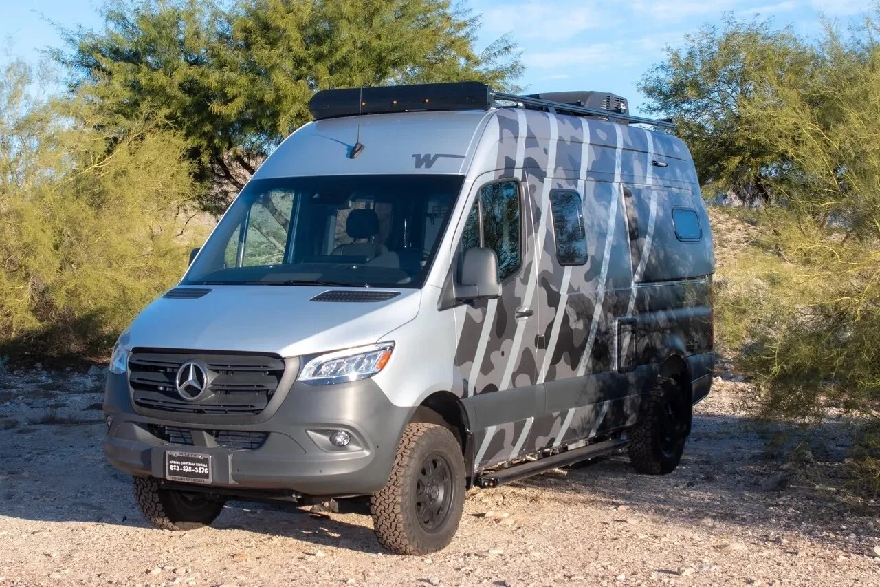
It’s not quite Beast (they rented out the tan one a few hours before I tried to nab it . . . so I had to settle for . . . Tiger Striped Urban Camouflage?) but it is 4WD and we can go on some of the standard gravel/dirt non-paved roads I know of. Other familiar areas we’ll just have to skip.
So this is what my admittedly rusty planning skills and experience has come up with for a (not really) 10 day trip. As always, very little of it is fixed. The plan just identifies places along the way we may want to photograph to give us options. It’s more than we could possibly see and one can never see it all so we’ll have to moderate our expectations. And of course, one great photography session can take 4-5 hours of the day, which means something else will have to be dropped for that day. But when you’re photographing in a great place, that’s what you want to be doing. The key is to have, for each day, a range of options so if one location seems uninspiring photographically (they are all inspiring emotionally), we just move on to the next possible location. So . . . here’s the rough itinerary.
Day 1: The first day will find us driving up scenic Highway 87 through the Tonto National Forest as we head towards our first stop, the Petrified Forest National Park. Some of our route planning has been made using the excellent Butler G1 maps (which are actually maps for motorcycle riders), which rates various scenic roads. If you need to get from point A to point B, why not take the most beautiful route to get there? After a slow drive through the Petrified Forest National Park and a likely hike at Blue Mesa, we’ll make our way up to Chinle and Canyon de Chelly.
There, we’ll spend the night at Spider Rock Campground, about a quarter mile from the rim of Canyon de Chelly (near Spider Rock of course). If we time it well, we’ll have some nice photography opportunities along the south rim that evening. This is only one of the two nights I have made reservations for during the trip - every other night we will be free camping or rolling into dry camping areas at an established RV park (hopefully the fewer the better).
Sorry, but I don’t have any images to share to give you an idea of what we’ll be exploring that first day. Day One will be all new to me too!!
Day 2: Our first morning from camp should find us photographing along the south rim and north rim of Canyon de Chelly. It would have been nice to take an extra day and to go into the Canyon, but that plan got dropped once we realized we could do a real road trip.
From there, we’ll head over to Monument Valley, a familiar location for most people . . . at least for anyone who has seen more than a couple of Western movies.
From Monument Valley we’ll head up to the Valley of the Gods. If it’s early enough, just before we enter it, we’ll turn off to see Goosenecks State Park. Otherwise, it’s drive the Valley of the Gods, find a good place to camp and photograph as evening sets in the desert. Hopefully we won’t get the crazy wind storms Ann and I saw on our visit there.
We’ll spend the night at the Valley of the Gods - there are numerous locations for us to settle down at within the valley.
Day 3: We’ll be up before sunrise at the Valley of the Gods because morning should be spectacular.
From there, we’ll be heading up the Moki Dugway, a nice windy road up an Escalante face (I.e., the background cliffs in the photographs above) that I would not think of doing with my normal navigator. But with Len . . . it’s time to get some of that aren’t-we-kinda-close-to-a-cliff stuff out of my system (ok, they say the Moki Dugway is pretty wide, wide enough for two mining trucks to pass each other, so there should be no issues). Once we’ve climbed the step, there will be a couple of nice viewpoints to check out and, hopefully, make some excellent images looking back over Valley of the Gods and Monument Valley.
From there, we head north a bit. If the time seems good, we’ll turn left for a drive through at Natural Bridges National Monument, though given our later destination, I suspect we’ll not be doing any long hikes at Natural Bridges.
That’s because we’ll be heading onward to the southern portion of Canyon Lands National Park, the Needles area, where we’ll first pass Newspaper Rock . . .
. . . before we hit Canyon Lands NP itself.
My suspicion is that we’ll feel like we don’t have nearly the time there we want (I think that will be a common theme on this trip, even when we do stay in one location for a long while).
Unfortunately, Arches National Park has a new timed entry pilot program this year and while I reserved a time slot for the next day, it’s at 11:00 am - way too late in the morning to have nice light. So I’ll be hoping to drive up to Moab, nab a dry camping slot for the night at one of several places I’ve identified, and hit the entrance to Arches before 6:00 am when anyone can enter without a timed entry pass.
Day 4: The next day, of course, will be spent at Arches National Park.
I suspect we will spend the entire day there, perhaps even into sunset. If not, we’ll head north a bit into the north section of Canyon Lands, the Islands in the Sky area, and photograph in the evening. My plan is to free camp on BLM land just outside of Canyon Lands NP and Dead Horse Point State Park so we’ll be ready for yet another early morning.
Day 5: What can I say, most mornings at Dead Horse Point are spectacular. Why wouldn’t we want to be there first thing in the morning?
Take note of the road you see on the canyon floor below in the picture above.
The rest of our morning will be spent checking out the views from the north part of Canyon Lands. When we’re ready to head out, we’ll be taking the long way out via Schaefer Basin Road to the bottom of the canyon and then along Potash Road back to Moab. It should be interesting looking back up at Dead Horse Point from that road I told you to note.
From Moab we need to loop around to Goblin Valley. If there’s time, I know of a nice set of petroglyphs we can stop to photograph that’s pretty much on the way.
Otherwise, we’ll spend the late afternoon and evening at Goblin Valley.
Unfortunately, by the time we (read: Ann) had the brilliant idea of a road trip, the Goblin Valley campground was booked, so we’ll have to free camp in the valley just outside the state park. Which is what we’ll do because you know where we’ll be the next morning.
Day 6: Some of my most excellent mornings (and evenings) have been spent at Goblin Valley and I’m hoping this one adds to the list.
From there, it’ll time to take care of a bit of business. So on Day 6 we’ll be stopping in Hanksville to do some laundry and stock up on foodstuffs.
Then it will be onto Capitol Reef National Park to check it out (time permitting).
I say time permitting because I really want to spend the late afternoon on the plateau beyond Factory Butte, which means backtracking a bit towards Hanksville. I’ve been checking the area out from Google Earth and we might just be able to take the road down the plateau if scouting shows it to be a normal dirt road as it appears on the aerial imagery. If not . . . well, the view from the top is fine as well.
Depending on what we feel like, we might just spend the night there, or head over a bit closer to Factory Butte.
Day 7: If it was anything like the last time Ann and I were there, the light of first dawn at Factory Butte will give us lots of photographic opportunities. Then again, so might the badlands area from the night before.
From there, we’ll have some choices to make. First, do we want to spend any real time in Capitol Reef National Park? If yes, we’ll hang out there a bit. Second, do we want to head south on Highway 12, which is a beautiful scenic drive through the mountains,
or do we want to go along the more rugged Strike Valley Rift that makes up the southern portion of Capitol Reef National Park?
I suspect I’ll push the choice onto Len. He gets to make all the hard decisions.
Either way, we’ll wind up around Boulder to photograph along the Burr Trail a bit, although unfortunately Hell’s Backbone Grill won’t be open for lunch in April. Our loss. Definitely.
Besides some photo spots near Boulder, we’ll be taking the spectacular stretch of Hwy 12 towards Escalante, eventually turning off Hwy 12 onto Hole in the Rock Road and taking it down to photograph at Devil’s Garden.
I can’t believe I’m saying this, but we won’t be spending the night there at our usual camp spot because I figured Len really should experience Bryce Canon at sunrise. So by the end of the day, we’ll be heading up to Bryce Canyon to spend the night at only the second reservation I’ve made for our trip.
Day 8: I suspect we’ll be freezing our butts off photographing at sunrise in Bryce Canyon (at this point, we’ll be at nearly 8,000 feet in elevation), but it should be worth it.
The rest of the morning will likely be spent driving along the canyon, photographing at the various viewpoints.
When we’re done, we’ll be heading out to take Cottonwood Canyon road to continue our journey south, possibly stopping at a couple of locations that are worth exploring. At the junction at Hwy 89, if there is time, we may take the two-mile round-trip hike into the Toadstool Hoodoos area. But from there, we’ll be heading to the relatively unknown but amazing photo/camping location Ann and I found by Lake Powell. During the day it doesn’t look like much, but at the edges of evening . . .
Day 9: For obvious reasons, we’ll be photographing there at sunrise as well.
But then we begin the long slog home. It won’t be a straight-shot because we’ll take a detour along the south rim of the Grand Canyon on our way back to Phoenix. We’ll take our time along the rim, because once we turn south again, the photography will pretty much be over and our goal will be to spend the night fairly close to Phoenix.
Day 10: The last day of the trip is all business. I’ll drop Len off at the airport fairly early in the morning so he can catch his flight back to Virginia. I then have to drop the vehicle off and figure out a ride back to my hotel by the airport so I can catch my flight the next morning.
That’s pretty much it. Plenty of things to do, plenty to see. And best of all, lots of road time with my brother. We unfortunately won’t be spending several days at any one location to photograph, but that’s the trade off. It’s a smorgasbord of photographic opportunities, not the fine dining meal of a single entré. One can enjoy either. Especially when the buffet is the desert SW.
Very little is set in stone however, so if we want to throw plans out the window and stay somewhere (or go somewhere else), hey, anything is possible. I know plenty of places in almost all the areas we’ll be at. Who knows, maybe another hurricane will make its way into Arizona and Southern Utah again and we’ll have to get really creative?
So make sure you keep your eyes open for our first trip postings. They won’t come until May, but I’ll make sure they come and (I haven’t told Len this yet), they should include photographs from the both of us. Oh, and I’ll probably have another pre-trip post that will provide a link that will allow you follow us via our inReach GPS device. Ann is not only the ideas person for this wonderful trip, she’s our technical support and has really come up with some great ideas to make our lives much easier.
The trip shouldn’t be too bad for a couple of geezer guys.