Iceland Trip Part 8 - Southern Iceland and the Eastfjords
In case you didn’t notice, the last trip post was, in a word, long. I had a difficult time breaking the post-Judy and John part of our trip into smaller segments that made sense. The natural breaking points in telling the story were either way too short or significantly longer than the first part of our trip. Sorry if they take more of your time to go through, but I opted for the longer stages. Anyway, there’s not as much story telling about them, I think because we’d become accustomed to the newness of traveling in Iceland, so they’re mostly a lot of pictures to give you an idea of how incredible Iceland is, so that’s an advantage. Who wants to read my babble anyway? So, back to the main feature.
Our goal for the first day was to drive to Þingvellir, but we weren’t going to go there directly. We opted to head south across the Reykjanes Peninsula, in part because there were a couple of stops we wanted to make. The drive through the mountains was lovely and we made a stop along the way.
Our first scheduled stop for the day was the Seltún Geothermal Area, just east of where the recent Grindavik volcano eruptions had occurred.
Like many of the geothermal areas in Iceland, it isn’t particularly large (by Yellowstone standards), but it is spread out, and even offered locations that required quite the hike, which we did not take.
On the main route at Seltún, the geo-features are diverse and interesting, and you’re able to get very close to them (and smell the sulfur!).
Ann and I took our time there and played around with our point-and-shoot cameras, pretty much the only option given the limited space to move around on the boardwalk and the number of folks that come and rush by on their way to the next stop.
Our next planned stop was one we found in one of our tour guides. Its name is the Hotdog Booth, in Sveitarfélagi∂ Ölfus. And yes . . .
. . . they serve hotdogs, the Icelandic way with crispy fried onions. I had mine with mustard. And yes, what everyone says is true - Icelandic hotdogs are better than US hotdogs.
Our destination for the end of the day was at the campground at Þingvellir. We took our time getting there, via a more scenic side-route and by the time we got there, the weather had changed yet again. So we set up camp to wait for what the weather app said would be a better tomorrow.
As usual, the weather app was right. It wasn’t beautiful weather, but at least it wasn’t rainy. Our first stop was Öxaráfoss, because we knew that as the day wore on more and more people would show up and shooting with our tripods would be out of the question. While the waterfall was beautiful, I was not pleased with the images I made of it. Sometimes your photographs aren’t as good as you think they should be. Öxaráfoss deserved better.
Regardless, Þingvellir is a wonderful place to explore.
As I explained in an earlier email, Þingvellir is on the west edge of the rift between the North American tectonic plate and the Eurasian tectonic plate. Actually, there’s a third tectonic plate - the Hreppafleki micro-tectonic plate that forms the floor between the uplifts of the two other plates.
With Þingvellir rising on the west, and the other plate rising on the east.
Þingvellir was where Iceland’s general assembly, the Alþingi, first met as the world’s oldest parliament and where the Lögber (Law Rock) is located, where every year the county’s laws were recited from memory.
And it is where the prime minister’s summer residence is located.
It’s a place chock full of history, geology, and beauty.
To be honest, I was surprised how interesting it was and how convenient it was to explore the various parts of the UNESCO World Heritage site.
Even when we wandered away from the main areas, there were lovely sites to see.
As planned, we camped that afternoon at Þingvellir at a different camping area than the first night. As one might expect, the views were great.
To no surprise, not long after we parked, one-by-one other campers came to park. I went out to dump some trash and realized that we had 7 camper vans with orange Netherlands license plates all parked next to each other (license plates blacked out for privacy purposes). What are the odds of that happening?
The next day was as anticipated, slightly better weather wise.
Our plan was to spend the morning photographing at Þingvellir and then continue our journey. We headed to another part of the park, north of the campgrounds, where we knew there were several trails and where there should be a lot fewer people. Unfortunately, after tries at several of the trail heads where we came across signs saying that the trails had been closed due to the recent heavy rains, I settled on a photograph of an opening in the lava field taken from the side of the road. We were quite disappointed of being deprived of an opportunity to explore an area one of the hosts of the campground said they liked to visit.
From Þingvellir we headed over to Brúrafoss, where we were definitely not disappointed. Yeah there were crowds and really only good views from the bouncy bridge (several of the side trails had been blocked off because of the slippery conditions), but the waterfall was beautiful and the water’s color is simply unbelievable.
It’s a stunningly beautiful glacial blue. Ann and I walked out with our point and shoot cameras, and went back to get our other cameras. Tripods weren’t really an option, but in-between the speed of the water, neutral density filters and in-camera stabilization, we were both able to get some nice movement in the water while still keeping the images sharp. Brúrafoss had to be our favorite large waterfall we saw in Iceland.
We’d spent quite a bit of time at Brúrafoss, so we headed over to have a late lunch at Flú∂a Sveypir, a farmer’s bistro that specializes in mushroom dishes. The mushroom soup and appetizers were delicious. As we walked out of the bistro, the rains started to fall and so we found a near-by campsite to wait out the rain and get ready to take off the next morning.
We really weren’t on a schedule, certainly not a tight one, so we afford to take things slowly and wait things out . . . so long as we kept heading east.
The next morning saw clear skies, and it became another day of waterfalls.
It was cold and brisk, but it was sunny, so we headed out early. First stop was Aegissi∂ufoss.
Then it was a short drive to Abaejarfoss.
After a short stop at a bakery, we headed over to Þorstein’s Grove, which of course, has a waterfall.
It was a lovely place and we were alone, so we spent quite some time there. Our quick check of what this location had to offer revealed it had a lot, to include rainbows and Elf Houses.
So we went back to the bimobil to get our cameras and tripods and enjoy the sunny day.
I’m sure the elves appreciated the company.
After an hour or so, other people started arriving (strange how that happens whenever a big gray vehicle gets parked in an out-of-the-way location), so we headed down a ways to visit the next waterfall along these cliffs.
This one was set back a ways from the parking area so we had a nice walk approaching the falls . . .
. . . and a trail that led up to the upper level.
As I’ve mentioned before, Ann and I found these much smaller waterfalls more interesting than the giant Niagra Falls-scale waterfalls that Iceland is famous for, so we took our time while we were there.
From there, we drove over to the Þórsmörk area where we decided to do the slow drive-by viewing of two more waterfalls - Seljakandsfoss and Gljúfrabui - for the obvious reasons (packed parking lots and crowds), opting instead to drive into the Þórsmörk valley. There we stopped to hike towards the Nauthúsfoss Canyon and decided we didn’t feel like doing the climb to see the falls and instead spent some time at the mouth of the tight canyon.
The day was beautiful and the hike back to the vehicle gave us time to appreciate the vastness of the landscape.
When we got back to the vehicle, we had a decision to make - do we try to drive further into Þórsmörk on an F-road famous for drowning cars at a couple of river crossings (Þórsmörk was one of the side-trips I’d planned to do with John and Judy that got cancelled due to the rain), or do we continue along our route eastward. We opted to play it safe and head towards Vik.
Along the way, we stopped off at a bakery that has possibly the best backdrop possible to grab some goodies for the next morning’s breakfast.
We arrived at Vik with no incidents, but while checking something up online we discovered some horrible news - we weren’t allowed to bring any Icelandic meats back with us to Europe. Faced with that tragedy, we were forced to cook the hotdogs we had already bought to bring back to the Netherlands. Bad news never tasted so good.
Vik greeted us the next morning with beautiful skies.
We’d planned a morning photo shoot of the Troll rocks, which I blogged about in more detail here.
As we made our way to the shore, it seemed like the light would give us something special.
But as the blog post explained, it largely left us frustrated because the light rarely made it to our desired subject.
So we had to play around with image-making, hoping and waiting for the sun to shine just a few hundred more yards out to sea. At one point, I decided to pull out my phone and show just how teasing it was, - we were standing in sunlight, but the Troll was in shadow. Sometimes, that’s just how it goes. By the time we decided to leave, the clouds had closed up again and it was so late in the morning that even if the sun had broken through, it would have had no drama. It was time to get back on the road.
Our route took us along the portion of the Ring Road we’d driven previously with Judy and John. Except this time, we’d take our time and pull over to look around whenever we felt like it. After about an hour on the road, the skies started clearing and we’d even stop and take a snap or two.
There was one location we knew we wanted to stop at - Fossalar - which we’d driven past on our previous excursion to Diamond Beach. Again, it’s a much more intimate and photographable waterfall, which Ann and I took full advantage of.
To the west of the waterfall was an old farming structure and . . . another set of waterfalls.
But the main focus of our attention was Fossalar, and we spent quite some time there. That was in part because crowds kept coming and going, so we often had to wait to get into a position we though would make for a good photograph, and in part because there were plenty of opportunities at different locations around this nice set of falls.
Eventually we were back on the road heading East, where we got much better views of the mountains and glaciers because of the clear skies. We quickly realized why the skies were so clear as the heavy winds buffeted the bimobil as we drove.
That didn’t stop us from periodically stopping to take pictures though, hoping to convey just how enormous the glaciers are. We considered spending the night at a campsite near the foot of this glacier below, but an inspection of the weather forecast made us realize that if we did, we’d likely be stuck there for a couple of days, and there was another location along the way that, if we were going to be ‘stuck’, that’s where we’d rather be. So we decided to keep going.
That didn’t mean we didn’t make short stops along the way, like this pull-out area overlooking Jökulsárlón and the glacial lake that leads to Diamond Beach (which we drove past when we saw the beach, again, largely barren of its famous diamonds).
The winds got increasingly worse as we drove along, and the skies gloomier with it. By the time we got to the Vestrahorn campsite, the winds were howling and I was exhausted from driving. But that didn’t stop me from taking a picture of the giant Vatnajökull glacier, with the town Höfn below its glacial arms, when I was done setting us up for the night.
The next day confirmed the weather forecast that had concerned us the day before. The wind that day was, in a word, brutal. On the Beaufort Wind scale there were Storm force winds, which lie between Gale force and Hurricane force winds. Yeah, brutal.
Most of the next day was spent inside the bimobil (being steadily rocked back and forth) with the periodic trip into the small reception area restaurant at the camping area for a change of scenery and an obligatory cup of coffee. Later in the afternoon, when things seemed to have died down a bit, we tried bundling up, grabbing our point and shoot cameras and heading down the spit road that leads to the Stokksness Lighthouse. We only made it about halfway down the spit before we gave up and turned around. Like I said, brutal. We did get a good view of Vestrahorn though.
The winds picked up again as evening approached and things were still rocking early in the morning. The forecast showed the winds dying by mid-morning, and we headed out for a real photo shoot when it actually happened.
It was a pleasant change from the conditions of the day before and Ann and I spent quite some time photographing from the dunes west of where most of the other visitors explore. As a consequence, we had plenty of untrammeled sand dunes to work with.
As I’ve mentioned before, in some respects we didn’t get to do as much serious photography during the trip as we had hoped, but when we did get the opportunity, it was a joy photographing.
We also wandered around the peninsula where the lighthouse is located, which offered different views of Vestrahorn.
And of course there was the more traditional views of that beautiful mountain.
The next day we back-tracked a bit to Höfn. It was time to do laundry.
There is a laundromat by the harbor, which had opened up earlier this year. Until quite recently (read: 2025) public laundromats were relatively unheard of in Iceland. I think most of the ones we visited during our trip had opened just this year. Supply I guess has risen to meet tourist demand.
Given that Höfn was a harbor town, we decided to take advantage of the opportunity for some fresh fish and, naturally, some Icelandic beer.
The next morning we took our time working our way through the first part of the Eastfjörds. One of the stops where we spent some time was at Fauskasandur, where we wandered amongst the coastal rocks looking for images.
Then began the in-and-out driving pattern typical of driving along fjörds.
The clouds, as you can see, had rolled back in. At least it wasn’t constantly raining. So we made stops whenever we thought it interesting . . .
. . . and of course the landscape was beautiful.
We opted to pass by a traditional campground and to stay at Camp Berunes Hostel/Camping, where we were one of only three campers at a larger farm operation. They also had a small restaurant bar for hostel guests, where Ann and I decided to have an after dinner drink. Yes, that’s where I had a Floki sheep dung smoked whiskey to go with my porter.
The next morning’s view from the campground was beautiful.
Our goal for the day was to backtrack to the nearby Nykurhylisfoss waterfall, and then to visit Djúpivogur, both on the other side of the fjörd from where we stayed.
Nykurhylisfoss was impressive.
And I decided to hike down the river-side trail a ways to make a few more images of the whitewater. Our stay there was shorter than it could have been because the rains had made the trail a bit sketchy so we decided to continue onwards with the journey.
By the time we got to Djúpivogur the temperatures had begun to drop and we started seeing periodic showers. After a great lamb stew lunch, we drove by one of their landmarks - Eggin í Gel∂ivik - a long row of giant eggs made up of the different minerals found in the area.
Me being me, I found the large oil tanks where we were parked at to be much more interesting subject matter.
Despite the winds and scattered raindrops, I couldn’t walk away from them until I felt satisfied I’d made at least a couple of decent images.
Heading back the way we’d come that morning, the skies immediately let us know what we were in for weather-wise for the remainder of the day.
Much like the Westförds, the Eastfjörds offered us heavy clouds, rains, and few areas to pull-out. Certainly more pull-outs than the Westfjörds, but not inviting given the conditions.
But like the Westfjörds, the views from the drive were fantastic!
So we took our time driving in-and-out . . .
. . . out and in, enjoying the scenery along the way. It turned into another long day of driving, but no particular location called out for us to stop for the day. As you can see, the thought of going up and over the mountains on one of the few dirt through-roads was pretty much out of the question given the snowy conditions at higher elevations. By that point, several of the Highlands F-roads had already closed for the year.
Our destination for the day wound up to be Rey∂arfjördur, which we first glimpsed as we exited a tunnel that saved us one additional long fjörd round-about.
The view point just at the exit of the tunnel also offered us a good view of a waterfall on this side of the mountain we’d just driven through.
The landscape in this part of the country can be quite rugged.
But it is nonetheless beautiful.
The rains shortly stopped and the forecast predicted they would not return until the middle of the next day (but with a passion), so after we secured our campsite, Ann and I decided to go for a walk to scout out potential morning photo locations. Given the campground was on the edge of town, and there was a trail leading out to the countryside, we opted to head outward and was rewarded for our choice.
The view back towards Rey∂arfjördur wasn’t half bad either.
We decided that we didn’t feel like cooking, so we walked into town to see what was open. We varied our route to see the ships in the harbor.
And then found out that all the restaurants in town had closed for the season. Even the couple of hotel restaurants were closed. We wound up eating at a gas station because the food store had already closed and we had nothing to prepare for dinner in the bimobil. . . serves us right!
The next morning we packed up, headed to pick up some groceries, and then drove to a location we’d scouted the day before, hoping the morning sun would give us a lovely view. The sun participated somewhat, but the rest of the clouds didn’t (kinda like Vik), so we never got the mountain and the valley floor lit up the way we were hoping.
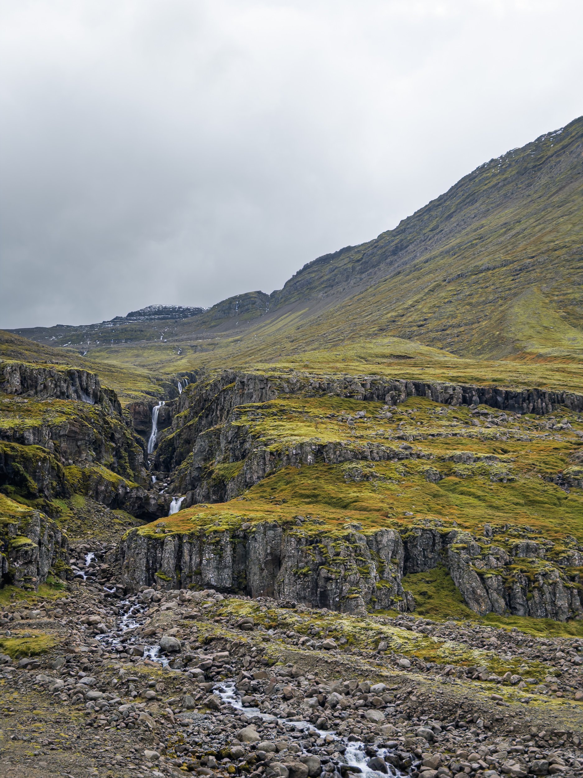
The clouds were clearly in a transition between fronts and the forecast for the next several days was . . . horrible. The previous night we’d discussed our options and we decided that the final leg of our trip would be spent revisiting some of the locations we’d started with. So we started heading out the valley, stopping at every pull-out to see what it had to offer.
At one, there was a lovely set of falls that, under better conditions, would have provided an opportunity to do some interesting photography. It was obvious that fall was starting to settle in and the colors would have been lovely under different lighting conditions. But we knew that wasn’t going to happen that day.
As we were leaving the valley, the distant blue skies hinted that we might have made a good decision.
Once into the next valley, on the way to Egilssta∂ir, one look back confirmed we were right.
And as it turned out, it was a good decision. As I mentioned, the forecast for the southern Eastfjörds had been for heavy rains. Well, that’s what they got. The next day we saw that there had been multiple mud slides that affected the Ring Road and a bridge between Höfn and Djúpivogur had been washed out - two days after we’d driven on it. We’d dodged a bullet.
I guess it really was time to revisit familiar places.