Phase 3 - Winging It. Part 2
The next morning I woke with excitement flowing through my veins. We had decided that, while on our way to Fire Point, we would take the long down-and-back detour to Point Sublime. And while the main road to Fire Point was a fairly good Forest Service road, the road to Point Sublime wasn’t - the Kanabownits Road is listed as a 4WD road on the maps, even worse than a high clearance road, and we were warned that it lived up to its rating. I was going to get to do some technical driving! Just not where we’d planned.
We had a full day ahead of us and not all that far to go distance-wise, so we took our time as we made our way deeper into the Kaibab Plateau. We knew there would be aspens along the way (face it, we were driving alongside Quaking Aspen Canyon) so we’d decided that after a bit, we’d find a decent place to stop and photograph.
Our first stop wasn’t ideal, but the next stop had us pulling out our cameras.

I picked up where I left off the the previous day and tried to make images that captured the chaos inherent in aspen groves.

That didn’t mean I didn’t also take advantage of the diffuse light offered by the overcast skies,

but I returned time and time again to the chaos theme.

And of course, there was the simple beauty of the changing aspen leaves.

We eventually packed it up and continued down the road. It wasn’t long before we made a left hand turn and headed south on Kanabownits Road. The road conditions changed considerably at this point. For much of the way, it wasn’t too bad.
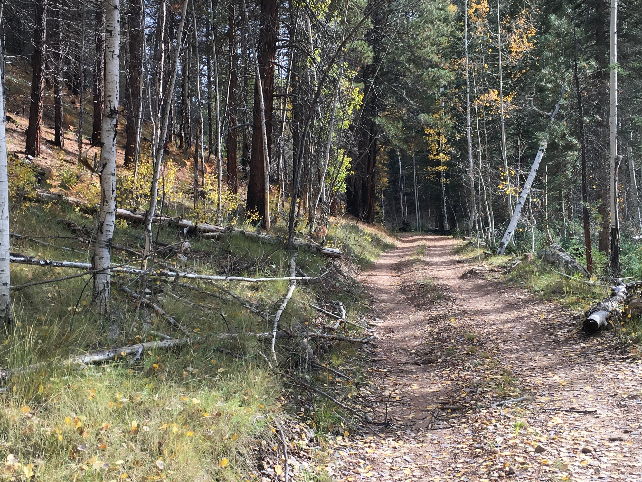
But don’t let this photograph fool you, the road went up and down canyons and became rutted and narrow on many occasions. It required some technical driving skills to not let the ruts, rocks, or roots damage the tires and leave us having to change a tire in a precarious location. And then of course there was the occasional deep mud hole - full of uncertainty as to how deep it was, what was under the surface of the water and whether we’d grip rock or slide on mud - all of which required a careful balance of going slow enough not to damage Beast if we hit something, but maintaining enough momentum to keep moving forward when we lost traction (even in 4WD). Also, there were several steep, narrow stretches that left us thankful that few people travel these roads - I simply can’t imagine doing some of those stretches backwards after coming face to face with another vehicle. Beast handled it like the pro she is - all she needed was to go into 4WD low when things got really steep or muddy! Me, well, by the end of the day I was mentally exhausted from having to constantly think my way through all the obstacles. But it was a blast!
After a couple of hours of technical driving, we made our destination - Point Sublime. Unfortunately, we hit it at pretty much the worst time of the day possible - high noon! Despite the fact that the skies were full of puffy clouds that let shafts of rays illuminate different sections of the Grand Canyon, there was a strong haze in the air and the effect was drastically less than it could (read: should) have been.
The photograph included here doesn’t do it justice. Still, I still managed to make a series of images that warrant their own blog post.

I could see reserving a backcountry permit to spend the night here just so we could be here for an evening/morning photography session. The view is . . . sublime.
We couldn’t stay until sunset because we knew the route we would have to drive in the dark was extremely challenging - we’d just driven it. I’m not that stupid to try doing it at night. And since dispersed camping isn’t allowed in the national park we headed back after a while, wanting to give ourselves plenty of time get to Fire Point.
Along one of the switch backs that climbed Crescent Ridge we ran into, of all things, a herd of Bison!
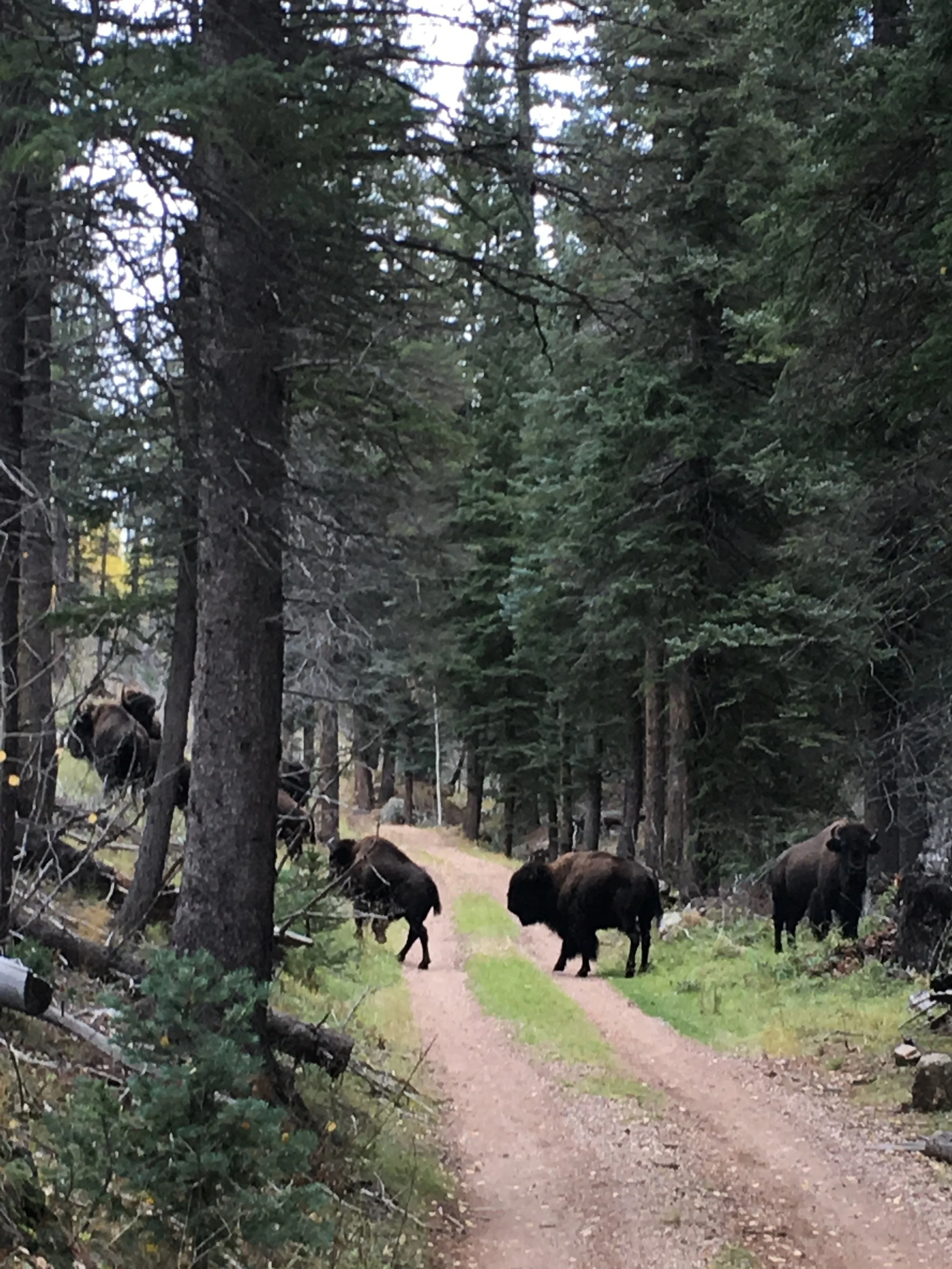
That was unexpected! They simply crossed the road and headed straight up hill!
The route back was uneventful. Beautiful, slow, technical, mentally exhausting, but uneventful. That was a good thing. Again, fun, but uneventful was good.
Once back on the main road, we turned left and headed towards Fire Point. It didn’t take too long to get there, especially since the Forest Service road was substantially better than the track we were just on.
The ranger’s advice was spot on. How’s this for a camp site view?

Other than making a couple of photographs of Beast, I didn’t take any real photographs. I was mentally exhausted from the drive and Ann gave me the perfect excuse not to. She found a lovely image and started asking me technical questions. I was glad to play tutor and simply enjoy the scenery and being with Ann.
Ann’s composition was a lovely one and as the sun started lowering, the light changed significantly, so we decided to simply wait it out with Ann’s same composition to see how the light and landscape changed over time. We would periodically walk around and check something else out, leaving the camera on the tripod, then to return and see how the conditions changed. And change they did.
After awhile, I pulled out my phone to make a photograph - which absolutely does not do the scene justice (yeah, I know, I should have pulled out my camera, even for a snap shot, maybe I should invest in a good point-and-shoot for these occasions [we gave our last one to our grandniece]).

From our vantage point we could see waves of showers crossing the Grand Canyon. Lovely, but a bit foreboding. As the sun set further, it began to cast a reddish glow on the clouds, . . .

and on the landscape.

Yeah, I can see coming back here again too. And even better, about a mile away from Fire Point is Forest Service land and a dispersed camping site we found! We wouldn’t even need a back county permit for that!
Much like the Caineville Wash area near Capitol Reef (which we didn’t get to photograph), discovering the Kaibab Plateau was a gem from this trip. Those two places will be high on the planning list for any future trips to the area.
The night as expected brought showers. If the clouds hadn’t been an indication, the showers we saw off in the distance were a good warning that we would not be dry in the morning. When we woke, it was drizzling and heavily overcast. And our view from Fire Point? It was like the old days when the TV networks shut down for the evening, there was a grey static that offered no views for photographs. Time to head out and to see if we could continue on our adventure as planned.
We knew weather was coming to the Grand Canyon, we just hoped that it would stay south and we could resume our itinerary. Driving northward across the Kaibab Plateau we saw rain, sleet and snow. But eventually, things cleared up a bit and the precipitation stopped.
Things were looking pretty good for a bit, at least until we started our way down off the Kaibab Plateau and eventually down towards Kanab. This is what we saw. .

The prospects didn’t look good. Well, nothing to do but have a good breakfast (at a really incredible French Bakery in Kanab!) and then swing by the BLM station
At the BLM station the forecast wasn’t good. Once the assistant at the desk heard the types of places we wanted to go to, she turned around and called a Ranger over. He was pretty excited about our planned routes with one little caveat - “You’re not going to be able to get to any of those places for at least three days. You’ll be lucky if they’re passable on Sunday. Monday should be possible if the rains don’t last more than a day or so. Even the locations along the side of the road - if you have to go more than 50 feet on a dirt road, I would advise against it, even with what you’re driving. At least you have the means to get yourself out if you’re near the road.”
We talked about alternative locations (go south, very far south, and/or west) and he pulled out an old copy of the BLM road map for the greater Nevada-Southern Utah-Northern Arizona area that he said should come in really handy when we do decide to do the trip we’d planned. He also pointed out some areas in southern Nevada/Northern Arizona that might be the type of thing we were looking for. Problem was, they were way off the beaten track and who knows what the photographic opportunities would be when we got there. He said we had a great itinerary, it was just unfortunate that now wasn’t the time to do it. Then he said the thing we’d heard so many times the past week or so, “Yeah, I’ve been living here a while and I’ve never seen this kind of rain before. Certainly nothing like it in October.”
Hopes shattered, we hit the road. And it wound up being a long day of driving. We first headed way south and west to Valley of Fire State Park near Las Vegas. By the time we got there the campground was full, the park was packed with people, dispersed camping was out on barren plateaus with dozens of other RV’s and the closest other camping in a natural area was 30 miles away by a reservoir where there would be boats, etc. That and, despite its beauty, our drive through the Valley of Fire didn’t inspire us (much can be said about attitude in photography, but when a place [or the people in it] turn you off, it’s hard to switch things back on). We agreed that it would be worth considering visiting Valley of Fire in the future (maybe when it’s so cold people didn’t want to visit here), but now wasn’t the time.
I suggested we head back towards St. Georges and try to re-giggle the itinerary I’d planned. So we drove back north up to St George, by which time it was approaching evening. We nabbed a hotel so we could figure out which way was north, and had a great mediterranean meal as we discussed next plans.
The next day was a laundry day again, so we did laundry at the best laundry mat we’ve been to. Strange that last sentence, but when you’re living on the road, things like that matter. Only thing missing was showers, but we could live without that - we’d had one (actually 2, because when you have them, use them) at the hotel.
Then it was back to the newly revised itinerary. We drove a bit north of St George, took a steep long road up the escarpment overlooking the area and found ourselves a nice little campsite.

And lest you think we didn’t have a view, think again.

Now this was more like it. Because we’d reverted back to the old itinerary, I’d already done a lot of research on different things to do while in this area. We just decided that we’d dip into that list and spend longer at these places than I’d first thought we would or could. Thank goodness for thorough planning.
Next on the itinerary - a hike into Yant Flat.