Phase 2 - Of Goblins, Hurricanes and Devils. Part 2
As planned, we were up and at it again in Goblin Valley State park early the next morning. And while the morning light was not as spectacular as the previous evening’s, it was a good morning of photography!
The clouds from the previous evening had stayed around, so we lost a bit of that early morning glow. Still, as the sun made its way towards the horizon, the pre-dawn light started to give us enough to make images.

So while the light was not as spectacular as the night before, the clouds gave us options to work with. Plus, the light was less dependent on the transient, incredible colors you get with clear skies.

That allowed us the time to think through potential images and, ultimately, to make a variety of image types.

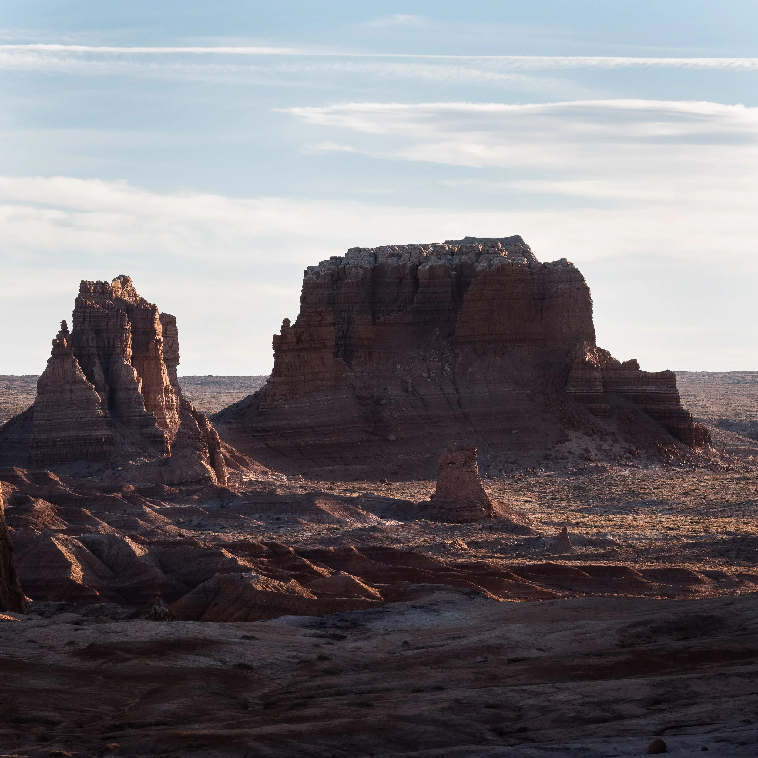
At one point I was framing an image looking towards the north and my eye caught a stunning cloud pattern off to my left. Realizing the quality of light was stupendous, with the light reflecting off the clouds and the clouds casting a shadow through the sky, I immediately spun my camera around to make the better of the images.

Eventually the sun poked over the horizon and between the clouds, flooding the valley with light.

The combination of low lying clouds and the geology of the place yielded a range of interesting light-shadow opportunities.

To include the formations I found so interesting the previous evening.
Our morning done, we took some time to regroup, have breakfast and think through the rest of the day. Our plan was to head down Wild Horse Road into the canyon and behind the San Rafael Rift like the previous day. Unlike the day before, we decided we’d stop for a hike as well. We opted for Little Wild Horse Canyon, because the guide books described it as the best slot canyon in Utah (though not quite as inspiring as some of the ones in Arizona).
The drive to the end of Wild Horse Road (well, at least to the part where turning around was a wise idea - we had no desire to spend our energies at self-recovery; better to spend our energy hiking) was fairly uneventful. Beautiful yes, but nothing that compelled us to stop and photograph. So we headed back to the trailhead. The sun was getting up in the sky, so things would be a bit harsh. We decided to leave most of the camera gear in Beast and go light. Ann grabbed her camera and a lens, I carried our emergency backpack (you have one in your vehicle don’t you?) and added a couple of big bottles of water, and of course I had my iPhone’s camera if needed.
It was a fun hike, one that we’d love to do again, early in the morning with our good gear. And, as you can see - it was indeed a tight squeeze at points.

Even with an iPhone, you could make some lovely images playing with the light and shadows in the slot areas.

And we would stop periodically for Ann to make a hand-held image. Ok . . . I made us stop a few times as well with my photo taking. While we were down there, we talked about how we would not like to be there during a flash flood. Strange how comments like that can come back to haunt you.

As we eventually made our way out of the canyon after several hours of exploring we encountered a steady wind that was whipping up sand all around us.
We headed back to the campground for showers (because if you have them - use them). We hadn’t thought much about the winds, other than the fact that they were picking up, until we realized that during the short time we’d been at camp a thin layer of dust had formed all over everything. Dust and camera gear, particularly on digital sensors that get exposed every time you change lenses, do not mix.
By late afternoon the wind was buffeting Beast and it was steadily rocking. Scratch the evening’s photo shoot. While the light was lovely, the wind and the biting sand being blown by it were not. So time for some housekeeping business.
It was at this point where I mentioned to Ann that I was worried about our house batteries, the batteries we run off of in the evenings. Usually during the day they quickly recharge and then run over 13 volts, dropping to 12.9 by nightfall and slowly dropping from there as we use them. Because one of the vehicle maintenance things I do is monitor them (though perhaps not as meticulous as I should - I don’t write anything down), I mentioned to Ann that I thought we were starting the evenings off at 12.7 or 12.6 recently. I didn’t think much about it because we were usually at 12.4 volts the next morning - a level we’ve often been at in the morning. But it has caused me to wait until daylight to charge camera batteries.
As for the morning, Beast was still rocking-in-the-wind when the alarms went off, so we opted for an extra hour or so of sleep. Things were still windy by the time we got up, made breakfast and packed for the road. We decided to hike into Goblin Valley, sans cameras, just to see what we’d missed.
I said sans cameras, but not sans iPhone.

While the winds were less steady among the hoo doos, there were still gusts that whipped up the sand. Not photographing was a good idea.

Still, like our hike into Little Wild Horse Canyon, it was enjoyable to explore the area.

As we headed on our way out, Ann asked to photograph from a location along Wild Horse Road that we’d scouted out the day before. As we pulled over, we realized that a big ridge to our south blocked the main winds and it was possible to pull out the good gear.
We hiked out about a quarter mile to a rise that overlooked a wash and the San Rafael Swell.

While my initial imagery used longer lenses to get details, I pulled out a wide-angle lens to get a feel for the vastness of the place and to capture the wash as it made its way down the swell into the valley.

It was a nice stop to make because the hike into it really reinforced the notion of how harsh an environment it can be, but taking the time to carefully explore and photograph the environment revealed just how beautiful it is, despite its harshness.

Next came perhaps the most surreal moment of the trip. Heading out of Goblin Valley State Park we headed back towards Capitol Reef NP. We stopped off in Hanksville for breakfast. While waiting for our breakfast I pulled out my iPhone and opened up the news. “Utah Governor Declares State of Emergency Due to Hurricane Rosa.” WTF!!!! This is Utah. October. A hurricane? Well, yes, it was. Although it would probably be a tropical storm by the time it hit Utah, it was expected to dump 3-4 times the amount of rain on southern Utah in a couple of days than it expects to get the entire month of October. The state of emergency was for slot canyons, like the one we’d been in the day before, and the off-road tracks that we were hoping to drive on for the rest of our trip. That meant a trip to the Capitol Reef NP office for an update was in order.
The news was, in some ways, better than we’d feared. Yes, the rain was inevitable, “No if about it, it’s coming!” The good news was that the emergency did not start until early afternoon on Monday. If we headed out immediately, we should be able to do our loop through Cathedral Valley and get back onto pavement within 24 hours. So we headed out!
The Virgin River was still at 10” at the river crossing at the beginning of the loop. Crossing it was no problem (Ann made a video of it from inside Beast). We were officially in the back country again.
After an initial uphill trudge, we started moving into the valley. The first real stop was at the Bentonite Hills, which resemble our painted hills (and is in part the reason why all the maps say “Roads impassible when wet.”).

We had lovely skies with clouds breaking up the landscape and offering some texture to our images.

Driving onward, we took a side road to check out the Lower South Desert Overlook. There, we saw what to me was the most elegant geologic formation of the trip, Jailhouse Rock. This was another side-trip where Ann and I hiked in without our tripods, brining only a camera body and a couple of lenses shoved into pockets. Still, even hand-held the place was beautiful.

The landscape along the ridge line remained us somewhat of Bryce Canyon, but the landscape was even more diverse. We discussed the possibility that, if the rains didn’t ruin things, perhaps we could make another trip this way during our several days in Capitol Reef.

In the parking lot there was a young guy who had a nice overloading set-up with his vehicle, but was obviously having problems. I walked over and asked him if he was ok and/or did anyone know he was broken down (his hood being up and him working on his engine was a dead give-away). He said yeah, his alternator had died and his brother and dad were on the way with a replacement (he was slow charging his battery with a solar panel). I told him that he’d be smart to get out of the area because rains were coming, he joked that his dad told him the same thing. He had set up to do night photography at the location (good spot for it), and woke up to find everything dead. Anyway, he thanked me for my offer of help (we would have used our satellite communicator to inform someone of the breakdown), and we went on our way.
We continued our drive northward and eventually arrived at the Upper South Desert viewpoint as the sun started making its way towards the horizon and the valley walls started casting shadows on the valley floor.

We spent the night mid-way through the Cathedral Valley Loop at the Cathedral Valley Campground. While we weren’t the only ones there, no one was within sound distance of us and we were able to relax for the evening.
The next morning we were up early and drove down the fairly steep Cathedral Valley Road in the dark. In the pre-dawn light the landscape didn’t look particularly interesting given that it was, again, fairly overcast. We drove onward to our destination for the morning, the turnoff to the Temple of the Sun and Temple of the Moon.
Given it was still overcast, we headed over to a formation called glass mountain. It isn’t a mountain, but rather a hill of naturally formed glass. Since our voltage was still running quite low, I took the opportunity to climb on top of Beast to wipe down the solar panels - perhaps there was just too much dust on them.
As you can see, the view from Glass Mountain wasn’t too bad, and the clouds had started to break.

When then the sun started to break through the clouds, Ann and I started photographing in earnest. My first efforts were of Temple of the Moon, taken with a long telephoto lens.

I then started making images with wider framing.

I can’t say that any of my wider landscape images worked, but I was so taken by the beautiful structures of the two temples that I couldn’t focus on anything else.
The remainder of our drive down Cainville Wash Road didn’t yield any more photographs, but not because we didn’t think the area was rife with images. We were stunned by the Cainville Wash and the beautiful forms within it. It is now tops on our list of places to visit if we ever plan a trip to Utah again. However, the weather forecast was in the back of our minds, so we decided to mark the map (which we did repeatedly) as a place to come back and photograph. (Best part is the area is on BLM land so we can camp wherever we want to out there when we do go back!)
We checked into our campsite at Capitol Reef and then decided to head down Scenic Drive to scout out Grand Wash Road and the Capitol Gorge Road. We stopped periodically whenever we saw an interesting area and I pulled out my camera at one location that had loads of interesting rock formations.

Ann pulled out the camera in Capitol Gorge to make an image of a tree in the gorge. I should have photographed her making it - it would have made for a good shooting the shooter story. There was plenty to explore!
By late afternoon we got the first of several rain showers. So we headed back to the main road to explore a couple of other areas. As we were leaving Scenic Drive, teams were moving in to close off the access roads to the two gorges - the state of emergency was coming into effect and any place that could be hazardous was blocked off.
We drove out to and hiked to check out Panorama Point and the Goosenecks overlook, and then stopped by one of the viewpoints along the main drive into the National Park.

Since the sun was lowering and casting a lovely light, we hiked across the highway onto Whiskey Flat by the main formation that gives Capitol Reef its name.

Despite the blue skies of early evening, we saw showers throughout the evening and night.
Our plan was to take advantage of the upcoming inclement weather and to take showers and do laundry. What else do you do while sitting out a hurricane in Utah? We also had dinner plans to meet our friends Gary and Paula in Boulder at . . . where else but Hells Backbone Grill. But first things first - a shower and laundry.
However, on the way out the rains had subsided (we realized later that they hadn’t really hit yet), so Ann and I stopped by a grove of cottonwood trees near the Capitol Reef visitor center. While most of the images did not live up to my expectations, this one turned out well in black and white.

When you’re on a trip like this, you never know where the adventure will come from. You wouldn’t think one would come from an off-day, but one did. First off, the showers were perhaps the best set-up we came across the entire trip. And while we had to wait a bit for laundry, we were not in a rush because it had started to pour. Hard. And we really had nothing much to do until dinner.
The showers/laundry mat were part of a larger complex of a small hotel, cabins and a general store with a small food area. I’d found a table on the covered outside part of the store, by the laundry area, and also by an electrical outlet. There we powered up everything we could (to include grabbing a couple of plugs inside the laundry area for our camera batteries). Given my concerns about the house batteries we had stopped trying to charge everything up in the evenings (and still the voltage seemed to be getting worse and worse by the day). Once Ann was settled in, downloading and working on images, I went in to do a bit of shopping.
Earlier, as I’d loaded up the washing machines, a couple of Germans had pulled up in a really nice overlanding vehicle - a rental that was properly equipped for going on rough tracks. I’d decided I’d ask them about their travels when I was done with taking care of business because, hey, we had time that day. Well, as I came out of the general store with some supplies, guess who is standing there chatting with Ann about photography?
I introduced myself, put our groceries inside Beast, and we started a conversation that lasted several hours. Our new friend was Armin from Zurich, on a 10 week trip in the US. The younger man was his younger son, who he was traveling with for a few weeks. After the younger son left, the older son would come out and travel with Armin for another few week stint. He’d noticed that Ann was at her laptop looking at photographs and he asked her if she was already processing her images. She was and the conversation was off and running.
Our conversation ranged from photography (about which we showed each other our photographs and talked about our approaches), to our countries and our travels. By the time we all had completed doing laundry (that’s why they were there too), Armin had invited us to visit him and his family in Switzerland. Sometimes you meet people on the road that you hit it off with. This was one of them.
There was not much to say about the rest of the day. The rain was hard, steady and occasionally a deluge throughout the day. I hadn’t seen anything like it since my time in Liberia. The drive to Boulder was not very fun or interesting because of the rain. Dinner at Hell’s Backbone Grill was superb as was Paula and Gary’s company. The drive back, again, wasn’t fun for the same reason.
As we pulled into the campsite that evening, I knew something was wrong. The house batteries were lower than ever, which meant that something was clearly wrong. While my mind was hoping that it was the solar panels not getting any sun because of the heavy overcast day, I knew better - our second alternator should have charged the batteries to full with all the driving we did that day. We weren’t going anywhere risky without the ability to live off the house batteries, so we had to troubleshoot the problem and get it fixed. That became mission #1 the next day.
Morning involved multiple phone calls to Sportsmobile, a phone-guided inspection of the electrical system by the head of Sportsmobile repairs (who knew there was a 110 amp fuse right by the alternator?) as well as informing them of the various indicators regarding the hose power system. The result was a recommendation to take the vehicle to a shop to see if the spare alternator was bad. It was. So Sportsmobile arranged for a new alternator (it was still under warranty) to be shipped to Loa, Utah, recommended we find an RV park to charge up our batteries, and hopefully we would be good to go after that.
Fortunately, Brians Auto had a space in the RV park they were developing (given that much of their business is based on repairing RV rentals) and we were able to plug in to recharge Beast’s batteries.

It wasn’t the type of place we like to spend our nights, but in this case, having a power hook-up meant that we’d have fully charged house batteries until the replacement alternator arrived.