Phase 1 - Of gorges, aspens, canyons and snot. Part 2
It was dark the next morning when we got up and, given that we’d camped at an even higher 9,500 feet elevation, very cold. After donning our long johns and brewing a pot of coffee to help warm us up, we made the short drive over to where we’d hoped to photograph that morning. Clouds had started rolling in, so we had a mix of cloud cover and starry skies waiting for us as we set up for our first photographs of the morning. We had to wait around a bit as the sun approached the horizon before we could make our first images of the day.

It didn’t take long for the atmosphere to begin reflecting enough light for us to be able to make the type of pre-dawn, soft-light images we so enjoy.

Over time I moved from the lower creek area to the hill adjacent to us to get a different viewpoint and to photograph a near-by stand of aspens.

By then, the sun rose above the horizon, so I turned back towards the field just as the sun’s rays started cutting across it. As I was framing for a view of the meadow, we heard the sound of elk bugling near-by. Suddenly, a herd starting cutting across the field and I quickly panned my camera on the tripod head to catch the herd in its fast dash. As you can tell by the cut-in-half trees, there wasn’t any time to compose the image or swap lenses to get a tighter view. Still, as always, it was great to have wildlife running around while you’re photographing.

Afterwards, I had more time to compose my images and kept working while the clouds crept in.

I returned to the lower elevations to photograph the landscape in the sunlight,

and, finally, climbed on top of Beast to get a slightly different perspective of the creek.

I was on top of Beast when the clouds finally filled-in the sky and we lost all direct sunlight. It was time to call it a morning and to head to our next stop - Bryce Canyon.
Not much is worth noting about the remainder of the morning other than the drive to Panguitch (and breakfast) was lovely, and we timed our arrival at Bryce Canon well. After nabbing a great spot at Sunset Campground inside the park, Ann and I decided to bypass the tourist-crowded National Park to explore the area in and around Red Canyon, about 10 miles west of Bryce Canyon.
As we approached the Red Canyon area Ann grabbed our off-road GPS, saw that the area was littered with tracks and said, “Why don’t we go down one of these?” So we turned right at the next track, mounted the GPS and started driving. At first the trail was wide and fairly level, working its way into a red-soiled canyon with lots of scrub and rock formations, which led us to stop a couple of times to look around, though we didn’t make any real photographs.
As the trail continued, it started entering a more forested area, with the soils changing to a tan color. The route was a bit rougher in patches, but it was no big deal.

At one point we passed an intersection that said “local trail” that looked rather narrow, so we stayed right. A few miles later we got to a bigger intersection that actually had signs and mileage distances. We looked at the directions, looked at the map on the GPS unit and decided to go left instead of right and take a longer loop back to the highway.
Ann was correct, we should have gone right. For about the first mile it wasn’t too bad. Then all of a sudden the trail narrowed, and then got extremely rocky and remained that way for several miles as it started to climb. Then we started seeing signs identifying it as an official ATV route - as it went up, and then down. It may not look like much, but the part you can’t see was steep and full of fairly big rocks and ruts.

While that stretch of the trail had some easy patches, it was rough and bouncy for the most part (face it, I don’t have images of the rough parts because I was trying not to damage Beast on those parts). It was slow going. Very slow. And Beast’s fox shocks got quite the workout.
We turned off onto another track when we could (I did not want to re-trace our route), which required an even steeper descent on an even rockier stretch of road. My technical driving skills were, how can one put it, put to the test. Eventually, we wound up on the “local road” we’d skipped earlier. It was a road the ranchers used (evident from the corrals and herds of cows we passed [looking at us like we were nuts]). It stayed on the low ground and avoided the rocky areas; however the trade-off was that it was heavily rutted so it wasn’t as if I could take it easy while driving.
By the time we got back to the pavement Ann and I agreed that maybe we wouldn’t just head off on wild adventures and that, perhaps, a bit of planning in advance was a good thing.
So we headed on down to the Red Canyon information center and got some information. The day before I’d noticed what seemed to be a wide dirt road leading off the main road just as you entered the Red Canyon area so I inquired about it. It was indeed part of Red Canyon and it led to two smaller canyons, so we decided to check them out.
While we took a few photographs, we really didn’t “photograph” the two canyons. We made some images of Losee Canyon (below) . . .

and stopped at Casto Canyon long enough to decide that we wanted to return there when we were less exhausted. We headed back to Bryce Canyon, stopped for dinner along the way and enjoyed a camera-free stop at sunset point before calling it a day.
We were up and at it again early the next morning. We got to the rim to photograph well before sunrise, but given the timing of the moon (off by a couple of days) and the scattered clouds, we had some strange effects (read: color distortions) with our pre-dawn photographs. Still, the alien landscape of Bryce Canyon yielded some interesting results.

As the sun hit the horizon I decided to try my hand with a traditional sunrise image. To be honest, the results surprised me.

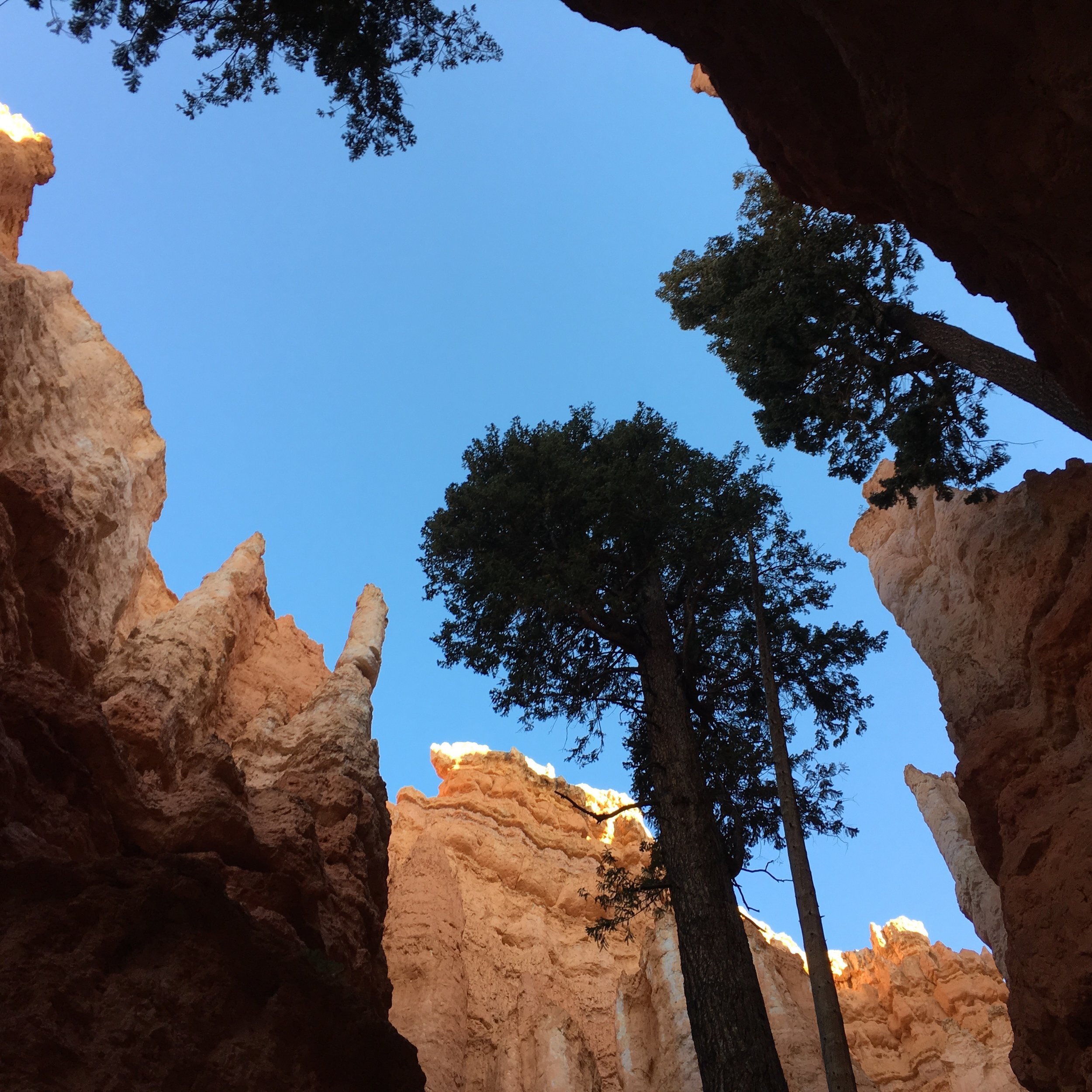
Once the sun comes up at Bryce, that’s when the fun part starts. Light starts reflecting around the hoo-doos and a panoply of opportunities arise. I wound up putting on my telephoto zoom lens and looking at details of the landscape.

I found myself hopping back and forth between the same handful of subjects because they would change dramatically as the sun increasingly rose.

I eventually forced myself to try to make a straight-up landscape image as the sun lost its early-morning golden glow. You can see from the image below just how different the light can be in different parts of the park.

As we ate breakfast that morning Ann and I decided we would stay at Bryce an extra day/night and hike down into the canyon. We then headed back down to explore Red Canyon some more.
We wound up stopping at Butch Cassidy Draw and, after first hiking into it, hiked into it again with our cameras. While most of my images wound up being less than satisfying (as is often the case in a new environment), you can see why we found the area so interesting. It definitely gave a much more intimate sense of the landscape than the Bryce Canyon rim.

And, of corse, anytime you’re in close proximity to an interesting landscape, there are detail photographs to make.

After the Butch Cassidy Draw, we decided to head down to our primary destination of the afternoon, Casto Canyon. We hiked into the canyon for about a mile or so, quickly getting off the trail and hiking instead along the dry wash bed. That gave us the opportunity to better see, and photograph, the landscape features along the sides of the canyon.

We were fortunate enough to have spotty cloud cover, which would periodically give us some texture in the skies, or shadows on the rocky hillside that we could use to help separate the layers of rock. For a bright, sunny day, the light seemed to cooperate a bit more than usual.

As is my habit, I shifted from landscape images, to the types of more intimate landscape details that I always find fascinating.

And for such a seemingly barren landscape, the diversity of vegetation in the canyon was impressive.

But much like Butch Cassidy Draw, many of my images from Casto Canyon didn’t quite live up to my expectations. Which only means that we have to get back to the area to photograph it again, and again, and again. . . .
Still, it had been a good day of photographing and, given that we were going to be up early the next day and hiking down into the canyon, Ann and I called it good and settled into a relaxing evening spent preparing for our hike.
The next morning started with an early rise. We didn’t start out with the hike per se, because we had other business to attend to before things got rolling. My trip calendar had two dates where we were keeping our fingers crossed hoping to get lucky. One was a few days down the road, and that was to nab an online reservation for a campsite in Zion National Park (reservations for sites can only be made within 2 weeks of the date of arrival). The other calendar notification was to secure an internet connection sufficient to order a book to be released that we knew wouldn’t sell out before too long. The book is by Bruce Percy, a British photographer we follow, and each of his previous books had sold out quickly. We knew he would be releasing a book during our trip, and the e-mail from a few days earlier said it would go on sale at 7:30 am our time so we had to be ready for that. Much to my anguish, when we woke up at 4:00 and upon checking my e-mail, I found out that the notice went out at 2:35 am. We had planned to drive to a location where we could get full LTE coverage, but now the clock was ticking. So with nervousness and only two bar LTE, I went to his website to order the book - things looked hopeful because I could get on his site and navigate with my cell phone. He had three options - the book only, the book and one print (limited to 100 copies) and the book and three prints (limited to 10 copies). I tried to order the three print set - sold out. Then the one print set - success! (We later found out that the book only - 2,890 copies - sold out in one day. The one-print set sold out in 5 days. If we’d waited until after the trip to order, we would have been out of luck.)
Book ordered and after our coffee and breakfast, we waited until the pre-dawn light before we started our trek for the day because, as you can see, it started with a steep series of switchbacks that took us from the rim to the bottom of the canyon in very short order through a stretch called Wall Street.

Once on the bottom, pretty much everything pointed to the fact that you were a lot lower than where you started from.
As we made our way out of the tight canyon floor, the light started filtering down and gave us some lovely reflections off the hoo-doo walls.

It didn’t take long for the canyon to open up, and we discovered an entirely different landscape and ecosystem than we’d expected at the bottom of the canyon.

The rich diversity of vegetation at the lower elevations of the park really surprised us. It was if someone had prepared a garden for people to visit; it almost seemed groomed, but in a natural way. There were signs of life, as well as the harshness of life, everywhere. It continually amazed us throughout our hike. We combined part of the Navajo Loop Trail with the Queens Garden Trail to basically hike through the area we had photographed the previous morning. In some of the images above you can see the trail we hiked on.
Aside from the vegetation and the landscape, perhaps the most interesting thing we ran into was a group of people that were being photographed with a camera that had three lenses. As we hiked past them I thought it through and told Ann I thought they were using an old, film stereoscopic camera. Eventually that group caught up with us and I stopped the owner and asked him. Yup, it was a stereoscopic camera from the 1950’s. The lenses to the left and right made images on 35mm film, and the center lens was used for focusing. He won the award for the most interesting camera of the day.
While it may be common knowledge (or common sense), but when you go down, you eventually have to go back up, and that we did. Still, the vegetation did its best to rise up in elevation and hung precariously on the steepening slopes.

At one point we ran into a cluster of trees that were nestled in a rocky nook along the trail. I couldn’t help myself - even without a tripod I had to try my best to make an image from the knurled, weathered wood.

We finally made it up out of the deeper canyon area, which gave us some excellent viewpoints from the narrow ridges we had to take to finally get back up to the rim.

There is no but about it - Bryce has a fascinating landscape. Even after we got to the rim, a solitary tree caught my eye and begged for one last photograph.

While some people seemed to almost run through the trail, Ann and I had taken a nice leisurely hike, stopping to photograph when something caught our eye, and stopping even more often to simply enjoy the beauty of the environment. We weren’t in a rush, so the hike took us several hours to complete. By the time we got back to beast, we were ready for lunch and the rest of the day’s activities - showers and laundry. It’s good to feel clean.
The next morning didn’t start out nearly as I’d hoped. I woke up feeling like I might be sick. I wasn’t sure, so I kept my mouth shut about it. But I wasn’t optimistic. Second, it was cold. Very cold. Very very cold. And windy. Still, we bundled up and trudged out to the edge of Bryce Canyon to photograph by the moonlight at the location we’d scouted at the end of our previous day’s hike.
Unfortunately, the imagery didn’t turn out the way I’d hoped. Unlike some of the successes we’d had at Yosemite with moonlit landscapes, things just didn’t turn out the way I’d hoped. Still, you keep working at it until you figure out what can work.

Despite the various directions I pointed my camera, in the end I wound up being frustrated with the results. Probably the moon wasn’t bright enough, or it was too low to the horizon for what I was hoping. In any event, I tried.

So I shifted course and tried to capture the feeling of pre-dawn and the star filled night sky. There, I think I met with a bit better success.

I guess I need to work on my technique a bit more for that effect, but now at least I have options for very early pre-dawn photography.
Ann and I were freezing by the time the sun and the early sunrise watchers came around, and we were ready to call it a morning. We could have stayed a bit longer, but we’d photographed that area already at sunrise and by that point I was pretty convinced that I was, indeed sick. Better to warm up and get somewhere where I can find medication to help pull me through the day.
So after breakfast, our first stop was in Escalante for me to get drugs, lots of them. Dayquil, nyquil, herbal remedies and lots of throat lozenges. Drugs acquired, we were back on the road.
The plan was to have lunch at Hells Backbone Grill in Boulder, so I’d prepared a range of options for us to stop between Escalante and Boulder. Given how my body was starting to ache, we opted for an off-road location that didn’t require any significant hiking to get to.
And how was it worth it. We took a side road off of a Highway 12 switchback that runs out along Spencer Flat. On the north side of the flat, it drops down to give a lovely view of the Grand Staircase Escalante. We stopped at a location I’d scouted out before and started making some photographs.

From that location you can see the diverse variety of landscapes the area has to offer.

And looking to the south, off in the distance you can see the plateau that borders the Hole in the Rock Road and the Devil’s Garden, which we hoped to explore in a few days.

We marked the location as one to return to on our trip back this way and headed onward to lunch.
By the time we got to Hell’s Backbone Grill I was feeling it so I opted for the soup as part of my lunch, hoping that some good fuel would help me weather the rest of the day. As we drove into the mountains and the aspens north of Boulder we didn’t do much more than pull over and scout things out - only to decide to continue onward.
Eventually we stopped at the Dixie National Forest information center where I spoke with the hosts (from Ohio) about possible locations for dispersed camping that we’d passed by and, because I’ve learned a thing or two in my travels, asked them if they had any particular recommendations and/or favorite spots to go to. They told us of an easy to get to location behind the info center, which is were we wound up spending the night. While the camping area was in a old aggregate mine site, right across the road was an aspen grove just waiting to be photographed. Figuring I might be on my last legs (I was right), we decided to start photographing right away.

This aspen grove was different than the other ones we’d visited. The trees tended to be a bit more mature, and there were open areas between the clusters of trees. That gave us a range of opportunities for the types of images we could make.

Also, the fields were a bit rocky, which gave us more elements to work with.

We took our time with image making, wandering the fields at our own pace. Then again, my pace was slowing down bit by bit as I was feeling it in my body and my nose. By mid afternoon I was going through handkerchiefs as if they were disposable kleenexes.

Eventually, we’d made a big loop around the fields to wind up by a set of trees not far from the road - easily identified by the graffiti carved into them.

At that point, I told Ann I thought it was time to head back to Beast. There, things finally hit hard and despite the fact that after dinner the early evening had some lovely light that made the aspens across the way glow, I knew I was up for nothing more than an early bedtime.
Evening turned into morning and me not feeling any better. I chose to sleep in and give my body time to heal itself, or at least get that process going. I can’t describe the disappointment I felt looking out the window at yet another missed opportunity to photograph under beautiful light. Still, I knew that if I let things get out of hand, I could be sick for quite a while. After about 12 hours of sleep, I finally decided my body was ready to go.
After some discussion we decided to head to the Pando Forest instead of heading back to some of the locations we’d seen earlier or to stay where we were at. The Pando Forest was high on our want-to-see list because it is a giant forest of quaking aspens that is essentially a single organism - all the trees are a clonal colony of a single male quaking aspen. So we headed north - of course after I downed my full range of medications.
We stopped for breakfast and then drove towards Fish Lake. As we approached Fish Lake we turned left onto a gravel road and started climbing towards Big Flat. Opting for the lower route instead of the higher route, we climbed slowly towards the north side of the mountain and quickly started passing through groves of aspens.
We stopped at a few locations, and even pulled out our cameras a couple of times. As the afternoon wore on, the light in the aspen groves started glowing and we just couldn’t help ourselves.

We eventually decided that we had to focus on finding a campsite for the night so we drove deep into the forest, only to find the perfect area occupied by several large RVs and other campers (and a plethora of ATVs). We decided to backtrack a bit and to take some side trails I’d noted on the drive up. Perhaps a bit rougher roads would discourage others. The question is whether any of them would also lead us to aspens.
Our first effort was a bust. The road was rough and narrow, which surely was enough to keep folks out, but as it popped over the rise and descended downhill, it really didn’t lead to any aspens. Sure, there were some scattered patches of aspens, but nothing to write home about (or to photograph), and most required a bit of a hike to get to. Face it, it was called Torgersen Flat, which reminded us of General Torgersen from Dr. Strangelove, so we shouldn’t have expected too much. Besides, if we’d spent the night there it probably would have taken our precious bodily fluids. So we backtracked yet again.
The second trail we turned off on was eve rougher than the first on the stretch by the road. But after about a half mile the trail rose a bit (and improved) and we saw what we were looking for. A quick glance down the road told me it was bound to wind down to a patch of bare ground I could see, and likely even farther into the forest ahead of us.

And as we drove down the hill, it became even rockier and rockier, which was fine by me. Beast could handle it, and others wouldn’t want to take it. I was confident (and correct) that we’d have the place all to ourselves.
It was just what we were hoping for. We had a variety of different aspens to photograph - different ages, different colors and different shapes.

We had free range of the place so we could go wherever we wanted and photograph at whatever scale we wanted. After taking my next dose of medication to ease the body aches, we started photographing in earnest.

As you can see, we’d found a lovely site to park Beast - right in the middle of our photo studio.

Ann and I went to work, pretty much photographing at will. I at least seemed to see one thing, and then another. When you’re feeling like that, it’s tough to make yourself slow down to try and make quality images each and every time. Fortunately, all the earlier work photographing aspens seems to have paid off and my image making started to become more clear.

It didn’t take long for the sun to go behind the adjacent hillside, which changed the quality of light. That helped me see a new range of images to make.

Despite my body feeling like crap, the extra sleep certainly helped my brain because I was able to think through different images so that I was seeing things at different scales and perspectives.

As the afternoon wore on we kept photographing, knowing that we only had one evening here and that you don’t always get the opportunity to photograph in that kind of light (and that I had caused us to miss the previous night’s light).

So we kept at it. And every time we thought we might be done, one of us would say, “Oh, I see one more image.” Which led the other to also see yet one more image.

We worked until the evening really starting to set in and the light changed yet again.

And, of course, there was always just one more image. Which in this case, was the last image of the evening.

After a quick meal in Beast, I needed to hit the sack as soon as I could. I was exhausted. Fortunately, because we were at our photo location, I could sleep in a bit and still take advantage of the pre-dawn light.
And that’s what we did. Up nice and early, bundled up against the cold (aspens grow only above 8,000 feet - we were considerably higher than that), and after our cups of coffee and my morning dose of medications, we were photographing again. My body was feeling considerably better after having two consecutive long nights of sleep, though my nose still runneth over. Profusely. But compared to the previous morning, I was ready to photograph - a little bit of snot couldn’t stop me from photographing.
It was like a new world, or better given I’d forgotten yesterday’s world. So some of the imagery was new.

But other subjects I’d recalled from the previous day’s photography and, being a bit more familiar with the place, led me to different images. This was the image I printed earlier this week.

Other trees that I had already photographed, I photographed again.

And others I saw anew because of the different light.

And there was one particular cluster of trees that had captivated me the day before that I returned to repeatedly that morning

And where I kept changing lenses, positioning and framing because I kept seeing the trees in different way

Which was as good a way as any to end the first phase of our trip. I was sick, but holding my own (except for the snot flowing from my nose), and by that time pretty exhausted again. But hey, I’m always exhausted after several hours of photography, even when I’m not feeling sick.
It had been a wonderful afternoon and morning of photography at the Pando Forest. However, our agenda had us heading into an entirely different environment and unbeknownst to us, an entirely different set of adventures.