Liberia
Two postings in one day? What’s gotten into me? Well, I had thought I was going to go out for a bit of an exploratory walk by the beach, but for the second day in a row, it’s decided to rain. Unlike yesterday (which got me out in the open), the rain today decided to start before I left home. So I figured I’d give you an idea of where I’m at.
As you can see here (and in the nice header Ann has created “Where in the world is Dan Terrell”), I’m on the West Coast of Africa. (I wonder if I’m proportionally along the West African coast at the same location Oregon is on the West Coast of the US?). President Ellen Johnson Sirleaf, in her memoir This Child Will Be Great, describes Liberia as “some 43,000 square miles of lush, well-watered land on the bulge of West Africa . . . .”
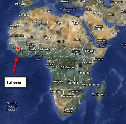
Liberia is bordered on the north by Sierra Leone, on the east by Guinea, on the south by Cote d’Ivoire (the Ivory Coast, but I’ve been warned to never refer to it as anything other than Cote d’Ivoire), and on the west by the Atlantic Ocean.
As I’ve mentioned in an earlier posting, Liberia as a country got its start when freed U.S. slaves were “returned” to Africa, and not all for altruistic reasons. There were, of course, already differing peoples living here. Liberia claims 16 separate tribes, with four different language families and 27 identified different languages. Historically there have been cultural and socio/political differences between the Americo-Liberians and Liberians who were born and raised “upcountry.” Much of the political unrest of the past century is due to these tensions. Anyway, Liberia has 15 counties (equivalent to our states) that vary in names that sound very familiar to more indigenous sounding names. By odd coincidence, there is a tribe called the Dan tribe, and the southern-most Liberian county is Maryland. So Liberians laugh when I say that I am Dan, born in Maryland (no, the Dan tribe is not from Maryland, it’s in the eastern part of Nimba County).
As far as development goes, most urban development is very concentrated along the coast, where the Americo-Liberians settled. Slightly more than 10% of the roads are paved, though that has been growing recently, with the main portion of that running from Sierra Leone on the north, south through Monrovia to Buchanan, about mid-way down the coast, as well as a portion of the main road that runs northeast from Monrovia past the Firestone rubber plantation to the mine (as in mining for iron ore) fields in Nimba County. There is no main road that runs along the entire coast line and I’ve been told that it’s pretty much impossible to travel from Monrovia to Harper, Maryland at the very south of the country during the rainy season.
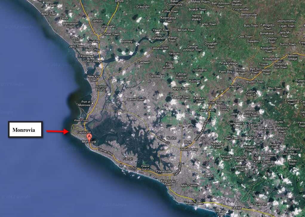
Monrovia is located about 20% down the coast line from Sierra Leone on a bulge that sticks out from the bulge of West Africa. It’s not a very large city and has relatively few tall buildings more than 4-5 stories high. However, a few taller buildings are under construction. Like DC, the city is built by swamps (to the immediate north) and has a Capitol Hill. I have not had a real chance to drive around, so I can’t say too much about the city other than it is very dynamic with lots of people out and about. There is not universal water, electricity or sewage, so life is not easy for most residents.
An interesting tidbit to note is that the airport, Roberts Field (located out by Firestone) was the alternate emergency landing field for the Space Shuttle in the event it could not land on either in California or Florida. We extended the runway at Roberts Field specifically for that purpose.

So where in Monrovia am I? I’m located at the western-most tip of Monrovia, pretty much exactly where the red arrow is pointing above. Below is a closer view. Just below the frame the coast turns towards the east, and just above the frame it turns eastwards as well. And as you can read on the map below, the area is known as Mamba Point (no I haven’t seen any mambas yet, and hope not to).
My apartment is in a building right across from the (now old) US Embassy - very convenient. Even though I’m supposed to move apartments, I’ve been told that I’ll stay in the same building. I won’t go into detail about either of the embassy locations other than to point out the location where I can surf the web (and upload blog postings) while looking over the ocean, and to note that, starting tomorrow, my commute to work will change from 3 minutes to maybe 10 minutes (that’s assuming I don’t get lost in the new building). Not bad!
One thing you can see on the right hand side of the photograph above is the random configuration of housing even in this area of the city (where embassies, UN missions and major government offices are located). If it looks like they are largely squatter shacks it’s because they are. Fortunately, it is fairly safe in this area and I have only been warned about entering one specific part of town (that’s a bit farther north on UN Drive and then to the left - Rule #1, do not make a left down the roads when going to the markets in the waterfront area!). While walking around the shopping areas yesterday, I knew I wasn’t in Kansas anymore, but I never felt unsafe.
So far I’ve found Liberians to be engaging, wanting to do business, and respectful when you say thanks, but no thanks.
So that’s it for now, maybe the rains will stop and I’ll get out for a walk!